I spent years specializing in online, interactive maps, and I could boast about certain accomplishments in that time, but I'm more excited to see my name on a printed book—made of actual paper—that you can find in a real-life shop!
Cincinnati in 50 Maps is the first of two books for which Belt Publishing recruited me as a cartographer. Though it was not known at the time to Anne Trubek, the founder and publisher of Belt who reached out to me, luckily I've always had some familiarity and fascination with Cincinnati.
The book was released in early December 2025 and is available now!

I was born, and for the most part raised, in the suburbs of Dayton, Ohio, some 50 miles up the road from Cincinnati. Dayton is its own place, but Cincinnati is easy to reach, and in some ways Dayton squarely in the Cincinnatisphere. (In fact one of my school classmates from third grade onward is now the mayor of Cincinnati.) As a child my growing interest in baseball—and therefore going to Cincinnati Reds games—is what first got me interested in the city.
Later, as I pursued undergraduate and graduate degrees in geography and cartography, I remained fascinated by the urban form of Cincinnati. A couple of my earliest serious cartography projects were focused on Cincinnati. Its history as one of the largest cities in the United States in the 19th century, the legitimate "big city" feel parts of it have, and the way it sits within its topographical constraints all continue to interest me.
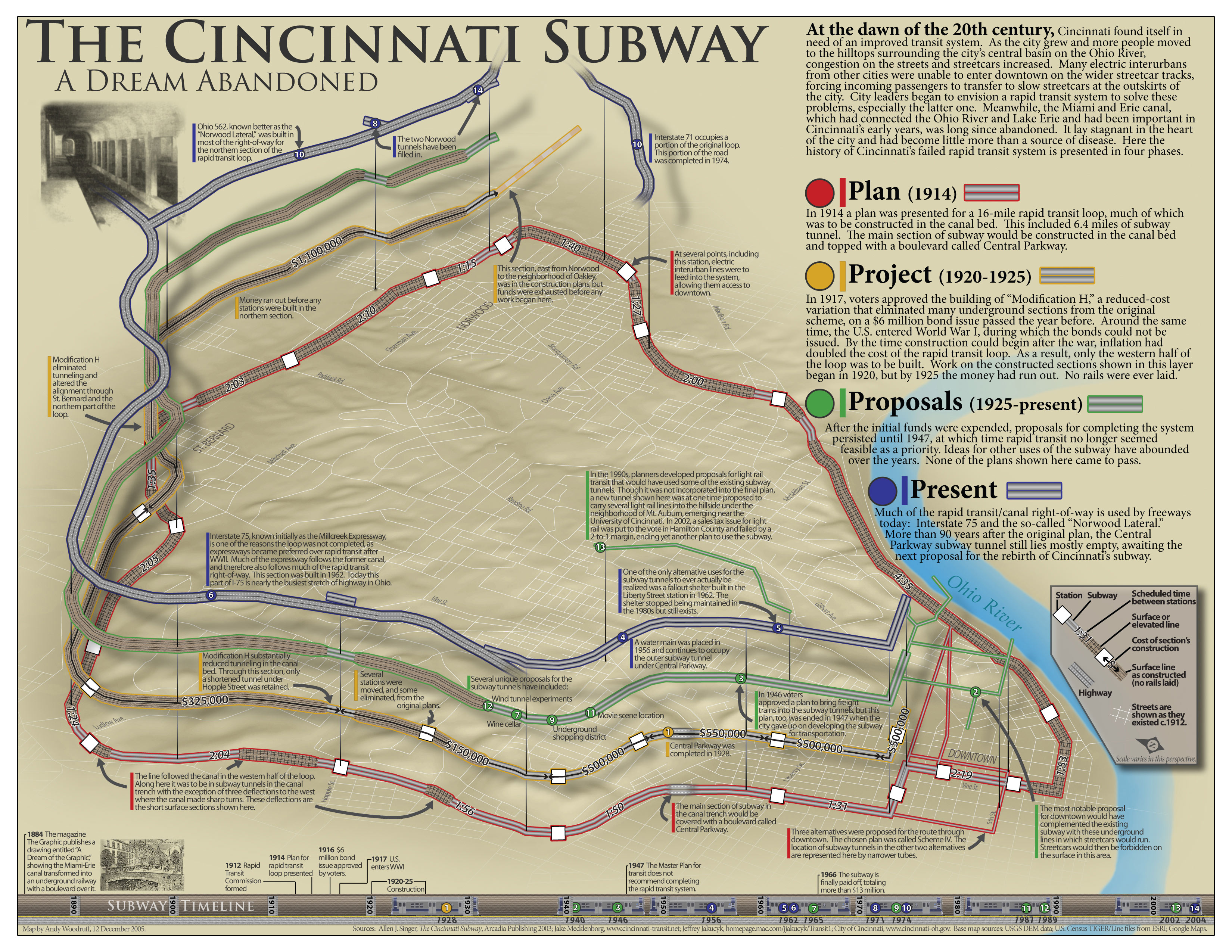
My final project for a graduate course in cartography in 2005
Back to present day. For this book, I was paired with author/editor Nick Swartsell, a journalist and more in Cincinnati. If I thought I knew Cincinnati, Nick proved me wrong! He came to the project with a long list of map ideas including topics I knew nothing about. He was also happy to work with most of the map ideas that I contributed from my lesser knowledge (or from stumbling upon interesting-sounding data sets). Nick organized everything into coherent sections and wrote the story of each map. In the end, we have 51 separate map subjects, but by my counting, 125 maps.
The first few books in Belt's "50 Maps" series used a basic palette of four or five colors, and I followed suit in my map designs. Late in the game for our book, however, the editorial team began to update and formalize the style and process (eyeing the continued expansion of the series), adopting the much more expansive Wada Sanzo colors as the standard. The book's designer re-colored and edited most of my maps to fit the new theme. Although they don't always look like something I would have designed, ultimately the maps are more lively and engaging than my original submissions.

My original map of Cincinnati art institutions (left) and the final published map (right)
Maps!
Enjoy a handful of sample maps from the book below, and please buy the book for anyone you know who loves or lives in Cincinnati! (It will be out in time for the 2025 holiday season!)

Former streetcar inclines

Terrain and scenic viewpoints around Cincinnati.

Ohio River crossings

And snippets of others. Don't worry, of course there's a chili map.